Breaking News: Trash Washes Up From Early Twentieth Century
Old Bottles Surface on the Banks of the Bayou
Site is a State Antiquities Landmark
Bonus: Some Geology and History
May 18, 2017
On a recent trip down Buffalo Bayou, pausing to document the springs seeping out of the banks, we stopped at one of our favorite spots: the wide sandy bank of what we call the middle meander — so named because it’s the middle meander in that 1.25-mile long stretch of the forested bayou targeted for destruction by the Harris County Flood Control District.
This sharp bend in the river is located at the eastern boundary of Memorial Park, with a small tributary flowing into it and very old high banks on the downstream side. It is a natural stormwater detention area, and elsewhere the flood control district is spending millions to build detention basins in or near our bayous. But here the district’s plan is to spend millions to fill in a detention area and dig a new channel for the bayou through the woods on the south bank of the bayou owned by the River Oaks Country Club. Why the members of the club would agree to that is a mystery. The plan also calls for grading the ancient high bank, leveling the area, and planting it all with turf grass. An access road for heavy construction equipment would be bulldozed through the public forest from the maintenance yard near Memorial Drive to the bayou.
Unusually, in this meander, the bayou deposits sediment on the outside bend, the park side of the stream, causing the bank to widen. (Normally sediment is deposited on the inside bends and picked up on the outside.) But the high outside bluff here is composed in part of very hard, resistant clay. This reversed phenomenon might also in part be the result of the blocking flow of the tributary shooting across the channel during rain events. And Geologist Tom Helm thinks that a fault running through the meander might have caused the bayou channel to shift somewhat to the southeast over time.
Here is a photo of Tom pointing to the downshifted layer of dark red clay in the strata of the face of the high bank, which is part of the tens-hundred-thousand years old late Pleistocene-era meander-belt ridges carved out of the earth at the end of the last glacial period, when giant sloths, zebra horses, and saber-toothed cats roamed through Memorial Park. We still have American alligators (alligator mississippiensis) and alligator gar from that period. The high cut banks of these meander-belt ridges are long-established characteristics of our west-to-east meandering streams in the Houston region and serve as as bumpers slowing the flow. The dark layer Tom is pointing to in the face of the high bank of the middle meander is offset by about three inches, possibly indicating a fault.
-
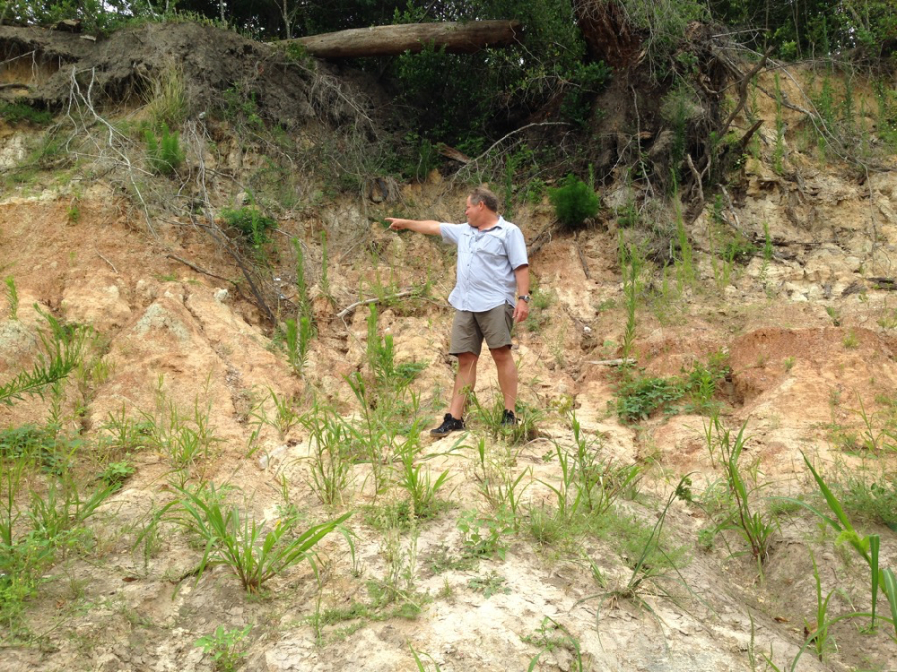
- Tom Helm pointing to his right. Invasive Johnson grass in foreground.
-

- Tom pointing down to his left. Photos April 29, 2017
Invaders. Pull Them Out!
When we stepped out of the canoe onto the sandy north bank of the meander, we were dismayed to discover invasive Johnson grass growing all over the beach. In the past this lovely sand bank was naturally landscaped with native smartweed, ground cherry and young box elder and black willow, all the proper native vegetation intelligently arranged by the bayou as it worked to stabilize the sediment and plan for new growth. But now this invader was taking over. We had seen it also at the boat launch in Memorial Park at Woodway. Very discouraging. Anyone who wishes to organize Johnson grass-pulling parties is encouraged to do so. The Memorial Park Conservancy unfortunately does not consider maintaining the banks or bayou woods part of its job, instead largely confining routine maintenance activities to mowing down the sedges and other wetland plants in the bogs of the park, leaving behind large, deep ruts. How nice it would be if the Conservancy respected the natural character and landscaping of our park.
A Surprise from the Past
As we inspected the springs that flowed out of the high bank, we were surprised to find a large pile of broken glass bottles and pottery embedded in the mud. The glass was thick and had an old-fashioned shape. The pieces looked very old. Geologist Bill Heins, who explores the banks of the bayou regularly with his dog, suggests that the bottles and pottery had washed out from an old trash dump in a filled gully higher up the bank.
Very possibly the pottery and bottles date from the era of Camp Logan, a World War I military training camp established in 1917, part of which would become Memorial Park after the war. Beginning in August of 1917 there was a large military hospital, as well as a landfill, operating on the north bank of the bayou, eventually occupying over 100 acres of what is now the Hogg Bird Sanctuary and extending westward into what is now the park’s South Picnic Loop, according to Janet Wagner, landscape architect and historian and former chair of the Harris County Historical Society. In 2014 Wagner wrote to the Corps of Engineers about the archeological significance of the bayou in the proposed project area. The hospital, she noted, served some 1,500 men and continued caring for veterans after the war. In 1919 the hospital and buildings were transferred to the Public Health Service, with some of them leased to the newly formed City-County Hospital District. In 1921 the Veterans’ Bureau took over the hospital and two years later began evacuating the veterans to other facilities around the state. One year later, in 1924, Will and Mike Hogg and their real estate partner, Henry Stude, purchased the hospital grounds and then sold at cost a total of nearly 1,500 acres of what had been Camp Logan to the City of Houston for the creation of Memorial Park.
In May of 2013 the Texas Historical Commission designated the former site of Camp Logan a State Archeological Landmark, now known as a State Antiquities Landmark. The designation requires that the landowner receive a permit from the historical commission before conducting any work on the site.
Here are photographs of the glass and pottery remnants we discovered on the bank of Buffalo Bayou in April 2017.
 Very old broken bottles and pottery shards on a bank of Buffalo Bayou in April 2017.


Will the New Memorial Park Master Plan Be for the People?
Nov. 5, 2014
Public Meeting Monday, Nov. 10, 2014, on proposals for a new Memorial Park Master Plan.

The prison-grade fence preventing public access to the $1.3 million SWA Group- landscaped not-a-canoe launch and secret wild woods with spring-fed pool in Memorial Park west of 610.
The Memorial Park Conservancy, Houston Parks and Recreation Department, and the Uptown Houston TIRZ are holding the second of four community meetings Monday, Nov. 10, 2014, about proposals for a new $1.8 million Memorial Park Master Plan.
The meeting will be from 6:30 to 8:30 p.m. in the White Oak Conference Center, 7603 Antoine Drive, 77004.
Go and ask them why they have locked up an entire forested section of our Memorial Park south of Woodway west of 610 and closed off access from there to Buffalo Bayou, access that historically had always been open to the public.
As far as we know, which is not much, the proposals for the new master plan make no mention of Buffalo Bayou. The previous master plan from 2004 recommended that the bayou be left alone as “a symbol of dynamic natural process.”
The 2004 plan reported that “a study of the Bayou’s dynamics and stability concluded that, after adjusting to increased urban runoff and water management structures upstream, the Bayou is vertically and horizontally stable, i.e., it is not deepening its channel nor is it dramatically widening its path.”
The landscape architecture firm of Nelson Byrd Woltz is leading the development of the new master plan. The City of Houston and the Uptown TIRZ plan to spend $100 to $150 million in tax money on capital improvements to the park in the next twenty years. None of that money is for park maintenance.
The Lovely Hidden Pool in the Secret Memorial Park Closed to the Public
Why Is the City Shutting Off Access to Buffalo Bayou in Memorial Park?
Nov. 2, 2014

The secret pool hidden behind a closed fence in Memorial Park. This lovely pool in the woods is filled with clear water from a spring-fed tributary of Buffalo Bayou. Photo by Susan Chadwick, Nov. 1, 2014.
We were exploring in the woods yesterday (Saturday, Nov. 1, 2014) behind the “prison-grade” apparently permanent fence now surrounding the mysteriously closed $1.3 million not-a-canoe launch, “erosion control” project and drainage outfall in Memorial Park just south of Woodway. This is the park area just west of Loop 610 that used to be called the Archery Range because it was in fact used as an archery range from the 1950s until about 1988.
The bayou here was the site of an old sandstone ford near the current Woodway Bridge that was known in the nineteenth century as Dutchman’s Crossing, and the woods contain the remnants of a large brick kiln (and bricks), charcoal manufacturing, and antebellum market garden, orchard, and plant nursery dating from about 1838 to the 1930s, according to landscape architect and historian Janet Wagner.
We were looking for the much newer paved pathway that until recently led to the bayou from Woodway and that only a few years ago was used by the sporting public to haul and unload their canoes and kayaks on the banks of the bayou underneath the 610 bridge.
For some reason the entire wooded area has been fenced off and the public pathway we were looking for has been eradicated. Only a few pieces of concrete remain, lost under the overgrowth.
Talking to Parks and Wildlife Commissioners and Harris County Commissioner Jack Cagle

The high bluff opposite the Jones Nature Center on Spring Creek. The springs on top of this bluff are believed to be the Springs of Santa Rosa, location of villages of the tribe of Canos, an Orcoquisa tribe, one of the least known tribes of North America but mentioned by early Spanish explorers. The bluffs along Spring and Cypress creeks are part of the same Meander Belt Ridges that form bluffs along Buffalo Bayou.
Aug. 26, 2014
What We’ve Been Doing Lately in Defense of Buffalo Bayou
Last week several of us went to the annual public meeting of the Texas Parks and Wildlife Commission held in Houston this year at the Museum of Natural Science. We wanted to urge the commissioners to protect our wild Buffalo Bayou in Memorial Park and the wildlife that lives in the bayou and its riparian forest.
We found the commissioners who were present attentive, sympathetic, and even encouraging. These included the Honorable Reed Morian of Houston and the Honorable Dick Scott of Wimberley.
Two days later we visited with Harris County Commissioner Jack Cagle during a canoe trip on beautiful Spring Creek in northwest Harris County sponsored by the Bayou Land Conservancy. Commissioner Cagle, a very likable, nature-loving fellow, represents Memorial Park, the River Oaks Country Club, both in the bulldozing project area, as well as points north and west.
Seeing What Will be Destroyed: Our Article in the Houston Chronicle
July 26, 2014
The Bayou Banks We Could Lose
Once again, a flood-control project threatens Buffalo Bayou
By Susan Chadwick for the Houston Chronicle
July 25, 2014 | Updated: July 25, 2014 3:21pm
We have pulled the canoe up to a clean, white sandy beach on Buffalo Bayou in the middle of the city. It’s still early morning, and all along our slow paddle from the bridge at Woodway great white egrets and a great blue heron fly ahead of us, leading us to our destination: the prehistoric cliffs and forested banks that could soon be obliterated by the Harris County Flood Control District.
It’s a bizarre project, all the more incomprehensible in that the project is primarily promoted by the influential Bayou Preservation Association (BPA), founded in the 1960s to prevent the flood-control district from bulldozing the natural beauty of Buffalo Bayou.
Read the rest of the article in the online edition of the Houston Chronicle. Note: This article also appeared in the print edition of the Chronicle on Sunday, August 3, 2014, Page G4.

Blue heron tracks in the mud on Buffalo Bayou. Photo by Jim Olive
Gloves Coming Off: The BPA Has Lost Its Way on Buffalo Bayou
June 25, 2014
Our response in the Memorial Examiner to Robert Rayburn, president of the Bayou Preservation Association

Over time, the mission and purpose of citizens’ organizations can erode and change course. Tragically, this is the case with the Bayou Preservation Association, founded in 1966 “to protect the natural beauty” of Buffalo Bayou against the bulldozers of the Harris County Flood Control District.
In a 1984 KUHT documentary, BPA founding member Terry Hershey warned that we must always be vigilant because the HCFCD would always try to find a way to strip and channelize our southern, slow-moving bayou and turn it into a drainage ditch. How shocking that the BPA itself is now promoting a Harris County project to bulldoze nearly 1.5 miles of our last remaining wild bayou in the middle of Houston in order to do just that.
Yes, We have Rocks in Houston. And No, That’s Not a Problem: That’s a Beautiful Pleistocene Cliff.
May 31, 2014
Floating down Buffalo Bayou past Memorial Park with only clear ground springs trickling through the fine sand and bright red clay banks. We put in last Friday morning under the Woodway Bridge, as they were spraying turf grass on the ugly drainage project that replaced the nature trail that used to exist downstream of the bridge. Led by a small white egret, with mockingbirds and cardinals calling in the trees and graceful herons crisscrossing in front of us, we floated with Memorial Park on our left all the way to the Shepherd Bridge.
This is a short video of the riparian forest the Harris County Flood Control District plans to destroy so that they can “restore” it.
What you can see when they are not flushing the 18,000-year-old mother bayou with sediment-laden water from the failing Addicks and Barker dams is: rocks. Yes, we do have rocks in Houston. Beautiful gray stone tables and ledges, huge slabs of ancient flat sandstone, mostly broken, alas, in a purposeful, barbaric act of destruction by the Harris County Flood Control District. Some years ago they drove a huge-wheeled crushing machine down the banks. Why? Who knows? Maybe they thought breaking up gajillion-years-old stone slabs would slow the water. Maybe they just don’t respect the bayou or our natural history.
But enjoy while you can the intricate, woven roots of boxelders, towering sycamores, and willows holding the historic banks together; the sparkling, natural springs surrounded by tiny green liverwort, seeping out of the layered red clay.
And regard the high Pleistocene cliffs we have here on the prairie. And no, that hard-packed cliff is not about to collapse or fall in the water. That’s what nature looks like, ladies and gents. According to the people who know this bayou well, that old cliff has been there like that for more than forty-five years, or maybe thousands.
See for yourself. This video is just under eight minutes long. If you want to watch a longer, fifteen-minute movie with informative dialog and text, you can find it here. Watch both!

Red clay bank and riparian forest on Buffalo Bayou. Memorial Park on the left.

Recent Comments