Breaking News: Trash Washes Up From Early Twentieth Century
Old Bottles Surface on the Banks of the Bayou
Site is a State Antiquities Landmark
Bonus: Some Geology and History
May 18, 2017
On a recent trip down Buffalo Bayou, pausing to document the springs seeping out of the banks, we stopped at one of our favorite spots: the wide sandy bank of what we call the middle meander — so named because it’s the middle meander in that 1.25-mile long stretch of the forested bayou targeted for destruction by the Harris County Flood Control District.
This sharp bend in the river is located at the eastern boundary of Memorial Park, with a small tributary flowing into it and very old high banks on the downstream side. It is a natural stormwater detention area, and elsewhere the flood control district is spending millions to build detention basins in or near our bayous. But here the district’s plan is to spend millions to fill in a detention area and dig a new channel for the bayou through the woods on the south bank of the bayou owned by the River Oaks Country Club. Why the members of the club would agree to that is a mystery. The plan also calls for grading the ancient high bank, leveling the area, and planting it all with turf grass. An access road for heavy construction equipment would be bulldozed through the public forest from the maintenance yard near Memorial Drive to the bayou.
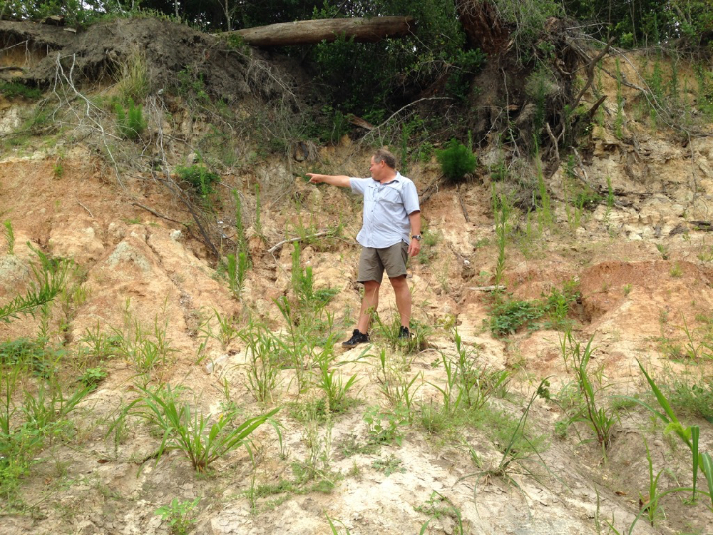
Unusually, in this meander, the bayou deposits sediment on the outside bend, the park side of the stream, causing the bank to widen. (Normally sediment is deposited on the inside bends and picked up on the outside.) But the high outside bluff here is composed in part of very hard, resistant clay. This reversed phenomenon might also in part be the result of the blocking flow of the tributary shooting across the channel during rain events. And Geologist Tom Helm thinks that a fault running through the meander might have caused the bayou channel to shift somewhat to the southeast over time.
Here is a photo of Tom pointing to the downshifted layer of dark red clay in the strata of the face of the high bank, which is part of the tens-hundred-thousand years old late Pleistocene-era meander-belt ridges carved out of the earth at the end of the last glacial period, when giant sloths, zebra horses, and saber-toothed cats roamed through Memorial Park. We still have American alligators (alligator mississippiensis) and alligator gar from that period. The high cut banks of these meander-belt ridges are long-established characteristics of our west-to-east meandering streams in the Houston region and serve as as bumpers slowing the flow. The dark layer Tom is pointing to in the face of the high bank of the middle meander is offset by about three inches, possibly indicating a fault.
-
- Tom Helm pointing to his right. Invasive Johnson grass in foreground.
-

- Tom pointing down to his left. Photos April 29, 2017
Invaders. Pull Them Out!
When we stepped out of the canoe onto the sandy north bank of the meander, we were dismayed to discover invasive Johnson grass growing all over the beach. In the past this lovely sand bank was naturally landscaped with native smartweed, ground cherry and young box elder and black willow, all the proper native vegetation intelligently arranged by the bayou as it worked to stabilize the sediment and plan for new growth. But now this invader was taking over. We had seen it also at the boat launch in Memorial Park at Woodway. Very discouraging. Anyone who wishes to organize Johnson grass-pulling parties is encouraged to do so. The Memorial Park Conservancy unfortunately does not consider maintaining the banks or bayou woods part of its job, instead largely confining routine maintenance activities to mowing down the sedges and other wetland plants in the bogs of the park, leaving behind large, deep ruts. How nice it would be if the Conservancy respected the natural character and landscaping of our park.
A Surprise from the Past
As we inspected the springs that flowed out of the high bank, we were surprised to find a large pile of broken glass bottles and pottery embedded in the mud. The glass was thick and had an old-fashioned shape. The pieces looked very old. Geologist Bill Heins, who explores the banks of the bayou regularly with his dog, suggests that the bottles and pottery had washed out from an old trash dump in a filled gully higher up the bank.
Very possibly the pottery and bottles date from the era of Camp Logan, a World War I military training camp established in 1917, part of which would become Memorial Park after the war. Beginning in August of 1917 there was a large military hospital, as well as a landfill, operating on the north bank of the bayou, eventually occupying over 100 acres of what is now the Hogg Bird Sanctuary and extending westward into what is now the park’s South Picnic Loop, according to Janet Wagner, landscape architect and historian and former chair of the Harris County Historical Society. In 2014 Wagner wrote to the Corps of Engineers about the archeological significance of the bayou in the proposed project area. The hospital, she noted, served some 1,500 men and continued caring for veterans after the war. In 1919 the hospital and buildings were transferred to the Public Health Service, with some of them leased to the newly formed City-County Hospital District. In 1921 the Veterans’ Bureau took over the hospital and two years later began evacuating the veterans to other facilities around the state. One year later, in 1924, Will and Mike Hogg and their real estate partner, Henry Stude, purchased the hospital grounds and then sold at cost a total of nearly 1,500 acres of what had been Camp Logan to the City of Houston for the creation of Memorial Park.
In May of 2013 the Texas Historical Commission designated the former site of Camp Logan a State Archeological Landmark, now known as a State Antiquities Landmark. The designation requires that the landowner receive a permit from the historical commission before conducting any work on the site.
Here are photographs of the glass and pottery remnants we discovered on the bank of Buffalo Bayou in April 2017.
 Very old broken bottles and pottery shards on a bank of Buffalo Bayou in April 2017.


State of the Bayou
Downed Trees. New Channel. New Riprap. Washed Out Sidewalks, Beavers, and Turtles
But Some Banks Naturally Rebuilding
Does It Make Sense to Repair?
Sept. 1, 2016
Updated Sept. 11, 2016
You could not step twice into the same river. Heraclitus
We finally had a chance recently to float down beautiful Buffalo Bayou to see how things have changed. Our trip took us past Memorial Park in the middle of Houston. We also biked along the bayou through Terry Hershey Park far upstream in west Houston below the dams to see what was happening there.
The good news is that some of the high banks that had slumped in Memorial Park and the Hogg Bird Sanctuary during the Memorial Day 2015 flooding are naturally rebuilding.
The bad news is that the River Oaks Country Club has added more riprap to the south bank, hard armoring the bank with ugly, damaging concrete rubble, including where it should not be.
Nature’s Miraculous Way of Restoring. For Free.
Houston has had multiple record-breaking rains and flooding since the spring of 2015. When Buffalo Bayou overflows its high banks, as it did in the Memorial Day flood of 2015, the banks in places sometimes slump or slide away. This happens when the overflowing water seeps through the ground and saturates layers of sandy clay that liquefy, sometimes causing the bank to give way. Buffalo Bayou is 18,000 years old, and this has been happening for a very long time.
This natural tendency to slump is one reason why we think attempting to engineer these banks as proposed by the $6 million Memorial Park Demonstration Project won’t work. It’s also the reason why we think building and repeatedly repairing sidewalks at the bayou’s edge is wasteful and foolish.

The south-facing high bank of the Hogg Bird Sanctuary collapsed during the Memorial Day flood in 2015. Now self-restored. Photo on August 4, 2016.
It’s Not Dead Yet
Flood Control Still Pushing Costly, Destructive “Stabilization” Project on Buffalo Bayou
July 31, 2016
It’s a pointless, wasteful, ill-conceived, and maybe illegal project to rip up and raze trees and plants and wildlife habitat, dig up the banks, plug up tributaries, dredge and reroute the channel along one of the last natural stretches of Buffalo Bayou in Houston. This is a dreamy stretch of the river in the middle of the city, filled with beaver, otter, alligators, fish and flying creatures, and even edible plants. It flows for more than a mile past our great public Memorial Park, a natural detention area and significant geologic site that features very old high bluffs and sandstone formations. All of which would be obliterated.
And after almost three years of adamant public opposition, the Harris County Flood Control District is still promoting the project, which will cost the taxpayers at least $4 million plus, not including future costs of maintenance and repair.
It’s mystifying why they want to do this, why they think it would even work, why they don’t realize that the bayou would wash it away or that it would simply all slump away, as has happened in Buffalo Bayou Park downstream, where taxpayers are footing the ever-mounting bill for constantly repairing the banks dug up and stripped of trees and vegetation by Flood Control.
Do They Not Have More Urgent Problems?
Surely, the flood control district has more urgent problems that require our hard-earned tax money. Harris County is one of the most flooded places in the country. And this project, billed as a “stabilization” and “bank restoration” program, will do nothing to address flooding and could even make it worse. The county should focus on the hundreds of miles of channelized bayous and streams unwisely covered in now-aging concrete that should be restored to something more natural and beneficial.
The project, called the Memorial Park Demonstration Project, was first proposed in 2010 by the Bayou Preservation Association under then board chair, Kevin Shanley, landscape architect and principal with SWA Group, the firm responsible for the ugly, obtrusive bridges, collapsing sidewalks, poorly-functioning dog park and non-functioning faux Hill Country fountain and stream in Buffalo Bayou Park.

This map prepared by the Harris County Flood Control District shows the areas to be excavated (yellow) and filled (orange) in the proposed Memorial Park Demonstration Project. Note also the rerouting of the channel. Memorial Park and the Hogg Bird Sanctuary, including a tributary, are on the north, with houses in between. The entire south bank is River Oaks Country Club golf course.
Can An Urban Stream Restore Itself?
Yes, With Room to Move. Free Rivers Are Healthier and Better for Flood Control
June 15, 2016
Updated with August 2016, April 29 and July 11, 2017, photos of self-repaired Hogg Bluff
By Susan Chadwick, Executive Director, Save Buffalo Bayou
This article is adapted from a presentation made at the Southwest Stream Restoration Conference in San Antonio, Texas, on June 2, 2016.
Save Buffalo Bayou is a non-profit organization founded two years ago to fight a public project described as a “restoration” project on one of the last natural stretches of Buffalo Bayou as it flows through the middle of Houston, past 1,500-acre Memorial Park and another 15-acre public nature preserve, the Hogg Bird Sanctuary. Since then our organization has expanded into broader, related issues. But today’s topic is restoration.
Here are some of the most common responses I would get when I would say that this mile-long plus stretch of the bayou is natural, along with what were some of the most common defenses of the project.

Sandy bank on a meander of Buffalo Bayou in Memorial Park. Photo by Jim Olive on April 2, 2016
The river’s not natural because the river changes.
It’s not natural because it’s been altered by high runoff from urbanization.
Trees fall into it.
It has terrible erosion problems. Look at those steep high banks!
It’s terribly eroded. Look at those sandy banks!
It’s eroding terribly. Sediment from the banks in Memorial Park washes up on the sidewalks of Buffalo Bayou Park we built downstream in the floodway right next to the river.
All that sediment carries bacteria. If we stop the banks from eroding so much sediment, we will reduce the bacteria. (Although sediment-laden Buffalo Bayou is less polluted than White Oak Bayou, which runs relatively clear and extremely foul due to being encased in concrete.)
And of course the big one: the river needs to be stabilized because it moves around.
Then there’s the argument, both implied and explicit, that prompted me to select this topic for presentation today: an urban stream cannot restore itself.
A Profound Misconception About How Nature and Rivers Work
All of those statements, of course, indicate a profound misconception about nature, about how a river works and how rivers benefit us.
A river is a living symbol of change. A living system. A dynamic process of nature that works for our benefit. Even the simple grains of sand work on our behalf to cleanse the water.
It’s for the Birds
Report on Plans for the Hogg Bird Sanctuary on Buffalo Bayou
May 11, 2016
First the positives about the presentation Monday evening, May 9, by the Houston Parks Board about plans for the little-known 15.56-acre nature preserve on Buffalo Bayou known as the Hogg Bird Sanctuary.
The sanctuary at the end of Westcott Street south of Memorial Drive is probably better recognized as the mostly impenetrable woods next to the parking lot for the Houston Museum of Fine Arts’ Bayou Bend Collection and Gardens, located across the bayou, accessible by a footbridge. Bayou Bend is the former home of the Hogg Family, who developed River Oaks and in 1924, along with partner Henry Stude, sold at cost to the city the 1,503 acres that became Memorial Park. (The Hogg Brothers also sold to the city at cost 133.5 acres of land intended to be part of Hermann Park. In 1943 the city sold that land for the establishment of the Medical Center, which provoked the continuing ire of their sister, Ima Hogg.) Ima Hogg, a cultural and civic leader and one of the city’s most revered philanthropists, donated the family house and gardens to the museum in 1957 and then donated to the City of Houston the woods on the north side of the bayou as a nature preserve.

The mouth of the tributary and ancient bluffs in the Hogg Bird Sanctuary on March 18, 2016. This tributary once flowed to the east across the upper part of the nature preserve into the bayou. Photo by Susan Chadwick
Ima Hogg a Defender of Nature and Public Parks
Ima Hogg, who died in 1975, was also an ardent conservationist, early civil rights activist, mental health activist, and defender of park space for the public, in particular Memorial and Hermann parks. In her letters to city officials over the years, available in the archives of the Museum of Fine Arts, she described her firm belief that woodland parks should be kept as natural as possible and criticized in a 1964 letter to then Mayor Louie Welch, who famously thought public parks unnecessary, the “alarming situation” of rapidly diminishing park areas in Houston and “throughout America,” including through construction in the parks by “worthy institutions” that really ought to look for building sites elsewhere, she wrote. Miss Ima was still angry that the city had “relinquished so much of the acreage” in Memorial Park for highways and a golf course and in an earlier letter to then city director of public works, Eugene Maier, demanded that the money the city received from the state for the highway land be used to acquire and improve additional park sites. Let’s guess that probably didn’t happen.
Once-a-Boat-Launch at Woodway to Re-Open by Mid-December
Meanwhile Buffalo Bayou Busy Replanting, Beautifying
Sept. 5, 2015
A contractor has been found at last to take down the heavy-duty chain-link construction fencing, put up some railing, spread some gravel and sod, and restore the informational sign in that western part of Memorial Park that was once a popular boat launch and is now referred to by public officials as a drainage outfall.

Native, edible amaranth in the foreground planted by Buffalo Bayou on the bank of the Woodway drainage outfall. Smartweeds, snoutbean, and other plants, mostly native but also some invasive, in the background. Native plants like amaranth and smartweed stabilize the soil and help prepare for new forest growth. Non-native Bermuda and St. Augustine grasses planted by contractors. Photo Aug. 28, 2015
Closed to the public for more than two years, including more than a year after the $1.36 million taxpayer-funded solar-irrigated “erosion control” project was completed, the ugly, massively enlarged outfall draining Post Oak Road is still officially a Texas Parks and Wildlife Paddling Trail boat launch. Previously it was also a forested area with a nature trail.
But officials with the Uptown Tax Increment Reinvestment Zone (TIRZ) 16 now seem genuinely eager to do “what we can to get it open to the public,” said John Breeding, administrator, at the Uptown board meeting in a Galleria high-rise last Wednesday, Aug. 26.
The board voted without discussion to award a contract for $219,272.10 to Jerdon Enterprise, LP, which was the sole bidder for the long-delayed project. With “add-ons” the cost could go to $335,615.10. That seems like a lot of public money for taking down some chain-link fencing, putting up some standard railing, laying down some loose gravel, etc. But apparently no one else wanted to do it.
Work on the Outfall Phase II is now scheduled to begin this month and be completed by December 15, 2015.
And if you’re confused about why a TIRZ and not the parks department or the city council would be making these decisions, well, it is confusing. But the TIRZ has control of the money.
Crazy Widespread Disappearance of Wetlands around Houston
Wetlands in Buffalo Bayou Threatened Too
Aug. 3, 2015
The Army Corps of Engineers is not keeping track of whether developers are replacing tens of thousands of acres of wetlands lost to development in the Houston region as required by law.
Wetlands, according to the Environmental Protection Agency, “are part of the foundation of our nation’s water resources and are vital to the health of waterways and communities that are downstream. Wetlands feed downstream waters, trap floodwaters, recharge groundwater supplies, remove pollution, and provide fish and wildlife habitat.”
Under the federal Clean Water Act, the Corps of Engineers is charged with protecting our wetlands.
A study by the Houston Advanced Research Center (HARC), reported by the Houston Chronicle Friday, July 31, 2015, found that “more than 38,000 acres of wetlands vanished in greater Houston over the past two decades despite a federal policy that ‘no net loss’ can be caused by encroaching development.”

Wetland photo by John Jacob, director of Texas A&M University’s Coastal Watershed Program, published in the Houston Chronicle, July 31, 2015. Printed with permission of John Jacob.
What Flood Control Is Not Telling Us
“Maintenance” Road Planned Along Bulldozed Bank
June 4, 2015
Updated June 8, 2015. See below.
Updated June 7, 2015. See below.
The Harris County Flood Control District is planning to create a 12-foot wide pathway for maintenance vehicles along the graded bank of Buffalo Bayou in Memorial Park.
The maintenance road parallel to the bayou is not included in the plans to “restore” the wild banks of the bayou submitted to the Army Corps of Engineers by the flood control district.
The district revealed the plan for what it is calling a “Monitoring Access Zone” at an invitation-only meeting Tuesday, June 2, 2015. The meeting was one of a series to develop a planting plan for the $6 million “erosion control,” “bank restoration,” “water quality improvement,” “flood conveyance” project known as the Memorial Park Demonstration Project. Apparently the planting plan is not progressing well, as at the meeting the district proposed planting tall fescue, an invasive exotic almost impossible to control. Tall fescue has been the scourge of Texas prairies for several decades at least.
“Tall fescue forms a near-monoculture and is responsible for the loss of otherwise undisturbed prairie remnants throughout Texas and the Midwest,” reports one of our landscape ecologists.
Well, so much for the district’s native plant expertise and commitment to a native-only riparian forest.

This beautiful tributary extending deep into the center of Memorial Park is labelled a “gully” by the flood control district. It will be plugged. Photo by Jim Olive on March 25, 2015.
No trees, no “better than ever” riparian forest
Little is known about the previously undisclosed but long-suspected “Monitoring Access Zone.” According to a source who was at the meeting, the 12-foot wide pathway will be planted with some sort of seed mix for several years until the district is certain the “restored” banks will hold. They won’t hold, of course, so this grassy, flat “access zone” is likely to be permanent.
Which means no trees, no “better than ever” riparian forest and wildlife habitat, banks bulldozed and leveled even through the so-called “no-work zones.”
What is Federal Jurisdiction
The district explained at the meeting that it was not required to reveal the “monitoring” road to the Army Corps of Engineers because it does not impact federal waters, presumably because the road will be above the Ordinary High Mark, which is the lateral limit of federal jurisdiction.
But it will not be above the OHWM, which in a significant section of the park extends deep into the forest as part of the flood plain, a natural detention area, including swales and wetlands, all of which are under federal jurisdiction. The road and the “bankfull bench” upon which it will sit will also fill and block at least two tributaries, which also are under federal jurisdiction, although on its plans the district labels both tributaries “gullies,” thereby attempting to remove the tributaries from federal jurisdiction. (See sheets 16 and 18.) Gullies are classified as an “erosional feature” by federal law. An actual gully leading from the South Picnic Loop parking lot is oddly labeled a “tributary.” (See sheet 16.)
So far we don’t know the length of “Monitoring Access Zone,” whether it extends along the entire north bank of the project area, including private property, or whether a “Monitoring Access Zone” will also be built on the south bank of the project, land which belongs to the River Oaks Country Club.
Guess we’ll have to ask the flood control district. And object to the Corps.
What else is the flood control district not telling us?

Snowy egrets flying past another tributary adjacent to the middle meander in Memorial Park, also labeled a gully by HCFCD. The banks here will be bulldozed, and the bayou filled in and a new channel cut further south through River Oaks Country Club property. Photo by Jim Olive.
Update June 7, 2015
There is no “road” planned for maintenance vehicles on the wild banks of Buffalo Bayou targeted for “restoration” by the Harris County Flood Control District.
Jason Krahn, manager for the district’s controversial $6 million project to “improve” one of the last natural stretches of Buffalo Bayou, wrote in an email to Save Buffalo Bayou on June 5 that “there is no road proposed for the post construction monitoring activities associated with MPDP [Memorial Park Demonstration Project].”
Participants in the district’s Vegetation Advisory Workgroup for the dredging and channelizing project had been told that for several years after “restoration” there would be a grassy 12-foot wide “Monitoring Access Zone” for maintenance vehicles to access the bulldozed and reconstructed banks of what is now a perfectly healthy historic natural area in need of no monitoring or maintenance whatsoever–other than picking up the trash and mitigating runoff from trails and parking lots.
This “Monitoring Access Zone,” workgroup participants were told, would remain in place until there was no longer any need for monitoring, replanting, watering, removal of noxious invasive vegetation, or repairs to failing “stabilized” banks, etc. Presumably removal of noxious invasive vegetation would not include the tall fescue, a noxious invasive plant, described above, that the district earlier this month was contemplating planting. Responding to objections, the district reportedly has changed its mind about the tall fescue.
Krahn said that monitoring activities would take place on both the north and south banks of the bayou in the project area, which includes Memorial Park and the Hogg Bird Sanctuary on the north and the River Oaks Country Club on the south.
He also wrote that “no work zones” on the bayou were in fact “no work zones,” despite the fact that heavy equipment would be driven over the banks, according to the district’s plans. However, above the Ordinary High Water Mark these “no work zones” would not be graded into bankfull benches, wrote Krahn, because “these are portions of the project area that already have the necessary geomorphic characteristics for a sustainable, stable channel.” A bankfull bench is a flat or sloping area above the bank of a stream that slows overflowing floodwater.
Asked to clarify the “Monitoring Access Zone,” Krahn has not yet replied.
But it’s not a “road,” Krahn insisted. So we won’t call it a “road.”
How about sendero?
Updated June 8, 2015
Project Manager Jason Krahn has clarified the “monitoring access zone.” In an email to Save Buffalo Bayou Monday morning, Krahn wrote:
“To provide for the monitoring access as outlined in the Atkins report [the post-construction monitoring plan included in the revised permit application], the District is working to define the appropriate spacing for vegetation within a portion of the flood plain planting zone. A spacing of 12-foot in width is currently being considered to allow for this access, or ‘monitoring access zone’ as you’ve referenced it in your previous email correspondence.”

Recent Comments