Breaking News: Trash Washes Up From Early Twentieth Century
Old Bottles Surface on the Banks of the Bayou
Site is a State Antiquities Landmark
Bonus: Some Geology and History
May 18, 2017
On a recent trip down Buffalo Bayou, pausing to document the springs seeping out of the banks, we stopped at one of our favorite spots: the wide sandy bank of what we call the middle meander — so named because it’s the middle meander in that 1.25-mile long stretch of the forested bayou targeted for destruction by the Harris County Flood Control District.
This sharp bend in the river is located at the eastern boundary of Memorial Park, with a small tributary flowing into it and very old high banks on the downstream side. It is a natural stormwater detention area, and elsewhere the flood control district is spending millions to build detention basins in or near our bayous. But here the district’s plan is to spend millions to fill in a detention area and dig a new channel for the bayou through the woods on the south bank of the bayou owned by the River Oaks Country Club. Why the members of the club would agree to that is a mystery. The plan also calls for grading the ancient high bank, leveling the area, and planting it all with turf grass. An access road for heavy construction equipment would be bulldozed through the public forest from the maintenance yard near Memorial Drive to the bayou.
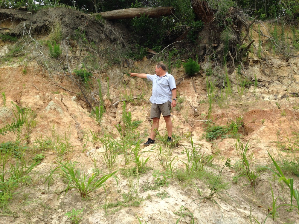
Unusually, in this meander, the bayou deposits sediment on the outside bend, the park side of the stream, causing the bank to widen. (Normally sediment is deposited on the inside bends and picked up on the outside.) But the high outside bluff here is composed in part of very hard, resistant clay. This reversed phenomenon might also in part be the result of the blocking flow of the tributary shooting across the channel during rain events. And Geologist Tom Helm thinks that a fault running through the meander might have caused the bayou channel to shift somewhat to the southeast over time.
Here is a photo of Tom pointing to the downshifted layer of dark red clay in the strata of the face of the high bank, which is part of the tens-hundred-thousand years old late Pleistocene-era meander-belt ridges carved out of the earth at the end of the last glacial period, when giant sloths, zebra horses, and saber-toothed cats roamed through Memorial Park. We still have American alligators (alligator mississippiensis) and alligator gar from that period. The high cut banks of these meander-belt ridges are long-established characteristics of our west-to-east meandering streams in the Houston region and serve as as bumpers slowing the flow. The dark layer Tom is pointing to in the face of the high bank of the middle meander is offset by about three inches, possibly indicating a fault.
-
- Tom Helm pointing to his right. Invasive Johnson grass in foreground.
-

- Tom pointing down to his left. Photos April 29, 2017
Invaders. Pull Them Out!
When we stepped out of the canoe onto the sandy north bank of the meander, we were dismayed to discover invasive Johnson grass growing all over the beach. In the past this lovely sand bank was naturally landscaped with native smartweed, ground cherry and young box elder and black willow, all the proper native vegetation intelligently arranged by the bayou as it worked to stabilize the sediment and plan for new growth. But now this invader was taking over. We had seen it also at the boat launch in Memorial Park at Woodway. Very discouraging. Anyone who wishes to organize Johnson grass-pulling parties is encouraged to do so. The Memorial Park Conservancy unfortunately does not consider maintaining the banks or bayou woods part of its job, instead largely confining routine maintenance activities to mowing down the sedges and other wetland plants in the bogs of the park, leaving behind large, deep ruts. How nice it would be if the Conservancy respected the natural character and landscaping of our park.
A Surprise from the Past
As we inspected the springs that flowed out of the high bank, we were surprised to find a large pile of broken glass bottles and pottery embedded in the mud. The glass was thick and had an old-fashioned shape. The pieces looked very old. Geologist Bill Heins, who explores the banks of the bayou regularly with his dog, suggests that the bottles and pottery had washed out from an old trash dump in a filled gully higher up the bank.
Very possibly the pottery and bottles date from the era of Camp Logan, a World War I military training camp established in 1917, part of which would become Memorial Park after the war. Beginning in August of 1917 there was a large military hospital, as well as a landfill, operating on the north bank of the bayou, eventually occupying over 100 acres of what is now the Hogg Bird Sanctuary and extending westward into what is now the park’s South Picnic Loop, according to Janet Wagner, landscape architect and historian and former chair of the Harris County Historical Society. In 2014 Wagner wrote to the Corps of Engineers about the archeological significance of the bayou in the proposed project area. The hospital, she noted, served some 1,500 men and continued caring for veterans after the war. In 1919 the hospital and buildings were transferred to the Public Health Service, with some of them leased to the newly formed City-County Hospital District. In 1921 the Veterans’ Bureau took over the hospital and two years later began evacuating the veterans to other facilities around the state. One year later, in 1924, Will and Mike Hogg and their real estate partner, Henry Stude, purchased the hospital grounds and then sold at cost a total of nearly 1,500 acres of what had been Camp Logan to the City of Houston for the creation of Memorial Park.
In May of 2013 the Texas Historical Commission designated the former site of Camp Logan a State Archeological Landmark, now known as a State Antiquities Landmark. The designation requires that the landowner receive a permit from the historical commission before conducting any work on the site.
Here are photographs of the glass and pottery remnants we discovered on the bank of Buffalo Bayou in April 2017.
 Very old broken bottles and pottery shards on a bank of Buffalo Bayou in April 2017.


Engineers Caused the Flood That Led to Creation of Flood Control District
A Fact-Based Response to “Engineers’ View” in the Texas Tribune
March 6, 2017
A few weeks ago the Texas Tribune published an editorial comment written by engineers Michael Bloom and Steve Stagner responding to the excellent investigative work on flooding in the Houston region, “Boomtown, Floodtown,” published by the Tribune and ProPublica on Dec. 7, 2016. See our summary of the report here.
In their TribTalk editorial “Boomtown, Floodtown Reconsidered, An Engineer’s View,” Feb. 6, 2017, Bloom and Stagner repeat a couple of erroneous statements commonly used by representatives of the Harris County Flood Control District in support of the district’s shaky position that paving over the prairie, i.e. development, is not contributing to flooding.
According to this point of view, our native tallgrass prairie and its associated wetlands are hardly better than concrete when it comes to slowing and absorbing rainwater. These deep-rooted grassland prairies, with water-absorbing root systems that can reach 12-15 feet into the ground or more, once existed around and upstream of Buffalo Bayou, in Katy, west of Houston, for instance, source of Buffalo Bayou, as well as up and down the coastal plain. Practical people are trying to preserve and restore what remains.
In support of their argument, Bloom and Stagner summon up a point commonly made by members of the local engineering community: that the 1935 flood on Buffalo Bayou that devastated downtown Houston and led to the creation of the Harris County Flood Control District happened even though the Katy Prairie way upstream was then a big natural tallgrass prairie.
This argument is wrong on two points. Read why in this fact-based response by Save Buffalo Bayou to an “Engineers’ View” published as a comment in the Tribune’s TribTalk.
Or continue reading to find out the answers. With links!

Prairie switchgrass with root system. Photo by Sky Lewey
Tracking Wildlife on the Bayou
Boys Scouting Part III
September 20, 2016
Boy Scout Paul Hung rallied his troop for the third floating inventory of the banks of Buffalo Bayou on a recent Saturday morning. Hung is documenting the tracks of wildlife as an Eagle Scout service project, and his fellow scouts in Sam Houston Council Troop 55 are helping.
Hung and other scouts have so far found over 130 tracks of animals including raccoon, beaver, possum, coyote, grey fox, bobcat, great blue heron, egret, otter, nutria, wild boar, and others. The tracks are being plotted on a map, and the information will be published as a pamphlet with the help of Save Buffalo Bayou, which is the beneficiary of the project.
Anyone who wishes to donate to help Paul Hung publish his Buffalo Bayou wildlife pamphlet can do so here.
About a dozen Boy Scouts and adult observers gathered with their Boy Scout wooden canoes at the Memorial Park boat launch at Woodway Sept. 10. It was a steamy morning, and they planned to paddle past Memorial Park and the Hogg Bird Sanctuary all the way to Lost Lake in Buffalo Bayou Park. Hung handed out clipboards and gave instructions for identifying and photographing the tracks and recording their location using a compass app on a cell phone. Nearby was the wooden box, built and recently installed by Troop 55 Boy Scout Saswat Pati, containing reusable bags for picking up trash on the bayou.

Members of Boy Scout Troop 55 headed downstream from the Woodway boat launch in Memorial Park to inventory animal tracks on the banks of Buffalo Bayou. Photo Sept. 10, 2016
State of the Bayou
Downed Trees. New Channel. New Riprap. Washed Out Sidewalks, Beavers, and Turtles
But Some Banks Naturally Rebuilding
Does It Make Sense to Repair?
Sept. 1, 2016
Updated Sept. 11, 2016
You could not step twice into the same river. Heraclitus
We finally had a chance recently to float down beautiful Buffalo Bayou to see how things have changed. Our trip took us past Memorial Park in the middle of Houston. We also biked along the bayou through Terry Hershey Park far upstream in west Houston below the dams to see what was happening there.
The good news is that some of the high banks that had slumped in Memorial Park and the Hogg Bird Sanctuary during the Memorial Day 2015 flooding are naturally rebuilding.
The bad news is that the River Oaks Country Club has added more riprap to the south bank, hard armoring the bank with ugly, damaging concrete rubble, including where it should not be.
Nature’s Miraculous Way of Restoring. For Free.
Houston has had multiple record-breaking rains and flooding since the spring of 2015. When Buffalo Bayou overflows its high banks, as it did in the Memorial Day flood of 2015, the banks in places sometimes slump or slide away. This happens when the overflowing water seeps through the ground and saturates layers of sandy clay that liquefy, sometimes causing the bank to give way. Buffalo Bayou is 18,000 years old, and this has been happening for a very long time.
This natural tendency to slump is one reason why we think attempting to engineer these banks as proposed by the $6 million Memorial Park Demonstration Project won’t work. It’s also the reason why we think building and repeatedly repairing sidewalks at the bayou’s edge is wasteful and foolish.

The south-facing high bank of the Hogg Bird Sanctuary collapsed during the Memorial Day flood in 2015. Now self-restored. Photo on August 4, 2016.
It’s for the Birds
Report on Plans for the Hogg Bird Sanctuary on Buffalo Bayou
May 11, 2016
First the positives about the presentation Monday evening, May 9, by the Houston Parks Board about plans for the little-known 15.56-acre nature preserve on Buffalo Bayou known as the Hogg Bird Sanctuary.
The sanctuary at the end of Westcott Street south of Memorial Drive is probably better recognized as the mostly impenetrable woods next to the parking lot for the Houston Museum of Fine Arts’ Bayou Bend Collection and Gardens, located across the bayou, accessible by a footbridge. Bayou Bend is the former home of the Hogg Family, who developed River Oaks and in 1924, along with partner Henry Stude, sold at cost to the city the 1,503 acres that became Memorial Park. (The Hogg Brothers also sold to the city at cost 133.5 acres of land intended to be part of Hermann Park. In 1943 the city sold that land for the establishment of the Medical Center, which provoked the continuing ire of their sister, Ima Hogg.) Ima Hogg, a cultural and civic leader and one of the city’s most revered philanthropists, donated the family house and gardens to the museum in 1957 and then donated to the City of Houston the woods on the north side of the bayou as a nature preserve.

The mouth of the tributary and ancient bluffs in the Hogg Bird Sanctuary on March 18, 2016. This tributary once flowed to the east across the upper part of the nature preserve into the bayou. Photo by Susan Chadwick
Ima Hogg a Defender of Nature and Public Parks
Ima Hogg, who died in 1975, was also an ardent conservationist, early civil rights activist, mental health activist, and defender of park space for the public, in particular Memorial and Hermann parks. In her letters to city officials over the years, available in the archives of the Museum of Fine Arts, she described her firm belief that woodland parks should be kept as natural as possible and criticized in a 1964 letter to then Mayor Louie Welch, who famously thought public parks unnecessary, the “alarming situation” of rapidly diminishing park areas in Houston and “throughout America,” including through construction in the parks by “worthy institutions” that really ought to look for building sites elsewhere, she wrote. Miss Ima was still angry that the city had “relinquished so much of the acreage” in Memorial Park for highways and a golf course and in an earlier letter to then city director of public works, Eugene Maier, demanded that the money the city received from the state for the highway land be used to acquire and improve additional park sites. Let’s guess that probably didn’t happen.
No Changes in Operation of Buffalo Bayou Dams
Release Rates May Be Looked At in Future
March 13, 2016
It was a dark and stormy night. Thunder boomed and heavy rain pelted the roof as a small group of us sat nervously in the middle of the rising Addicks Reservoir in far west Houston listening to the district commander of the Army Corps of Engineers tell us Addicks and Barker dams are safe.
Flanking Col. Richard Pannell last Wednesday, March 9, was a panel of officials from the Corps’ Galveston District office, as well as representatives from the Harris County Flood Control District and Granite Construction, the company awarded the $71.9 million contract to replace the leaky conduits in the 70-year-old earthen dams. The audience was a small crowd of about thirty hardy citizens who had braved the heavy traffic and heavy rain and managed to find the Bear Creek Community Center in the middle of a dark, wet forest despite the wrong address in the Corps’ public notice.
Col. Pannell made a thorough and convincing presentation of the history of the dams, the current problems, and what is being done about them. Among other work, the conduits in the two dams will be entirely replaced by new conduits in separate locations. This process will take about three years. He emphasized that the dams were in no immediate danger of failing and explained that the dams are labeled “extremely high risk” because of the potential consequences to Houston, the nation’s fourth most populous city, in the unlikely event that the dams failed.
Dams Operating Normally Despite Leaks
There were several questions about the capacity of the dams and the impact of repairs on the rate of future releases of water impounded behind the dams. The pattern of extended high releases and rapid drops has been criticized for damaging property on the bayou and killing trees and vegetation that control erosion.
After the enormous Memorial Day storm last year, the Corps began releasing impounded stormwater at 3000 cubic feet per second (cfs) for the first time. Normally the release rate is limited to 2000 cfs as measured by the Piney Point gauge. The Corps does not release water from the dams during a rain event, and the high releases began on June 1 and continued for ten days, finally dropping on June 12. The banks were already saturated from the storm, and the damage from the extended high flow was plainly visible up and down the bayou.

Tree on private property downed by extended high water releases from Buffalo Bayou dams in June 2015. Photo courtesy of Don Jones.
Film: Letting the River Heal
Learning to Respect A River’s Natural Process
October 18, 2015
“We have to be patient,” says Steve Nelle, Natural Resources Conservation Service, retired.
“Nature’s going to recover that area at her own timetable in her own way. It’s best to accommodate that natural process.”
Watch this moving and informative 14-minute documentary about a river’s natural process and Best Management Practices for protecting against erosion and preserving a river’s important role in cleansing our water, slowing storm water and runoff, and providing wildlife habitat.
All of this applies to Buffalo Bayou as well as our other bayous, creeks, and streams in Harris County. Even a small riparian buffer of native trees and vegetation a few feet wide is important for our waterways and the cleanliness of the water flowing through our neighborhood streams and into our bays and oceans. But on Buffalo Bayou, especially as it flows past Memorial Park, we are fortunate to have room for the river to move. Letting the river be a river is the most current scientific thinking on river management, even in cities. A dynamic river creates the most beneficial and biologically diverse environment.
Let’s work with nature, not against it.
This lovely, short film was made about the Blanco River and the impact of the 2015 Memorial Day flood on Wimberly, Texas. We can all learn from it.

Steve Nelle, Natural Resources Conservation Service, retired. Still photo from the documentary, “Letting the River Heal.”
Once-a-Boat-Launch at Woodway to Re-Open by Mid-December
Meanwhile Buffalo Bayou Busy Replanting, Beautifying
Sept. 5, 2015
A contractor has been found at last to take down the heavy-duty chain-link construction fencing, put up some railing, spread some gravel and sod, and restore the informational sign in that western part of Memorial Park that was once a popular boat launch and is now referred to by public officials as a drainage outfall.

Native, edible amaranth in the foreground planted by Buffalo Bayou on the bank of the Woodway drainage outfall. Smartweeds, snoutbean, and other plants, mostly native but also some invasive, in the background. Native plants like amaranth and smartweed stabilize the soil and help prepare for new forest growth. Non-native Bermuda and St. Augustine grasses planted by contractors. Photo Aug. 28, 2015
Closed to the public for more than two years, including more than a year after the $1.36 million taxpayer-funded solar-irrigated “erosion control” project was completed, the ugly, massively enlarged outfall draining Post Oak Road is still officially a Texas Parks and Wildlife Paddling Trail boat launch. Previously it was also a forested area with a nature trail.
But officials with the Uptown Tax Increment Reinvestment Zone (TIRZ) 16 now seem genuinely eager to do “what we can to get it open to the public,” said John Breeding, administrator, at the Uptown board meeting in a Galleria high-rise last Wednesday, Aug. 26.
The board voted without discussion to award a contract for $219,272.10 to Jerdon Enterprise, LP, which was the sole bidder for the long-delayed project. With “add-ons” the cost could go to $335,615.10. That seems like a lot of public money for taking down some chain-link fencing, putting up some standard railing, laying down some loose gravel, etc. But apparently no one else wanted to do it.
Work on the Outfall Phase II is now scheduled to begin this month and be completed by December 15, 2015.
And if you’re confused about why a TIRZ and not the parks department or the city council would be making these decisions, well, it is confusing. But the TIRZ has control of the money.
While We Wait
The Flood Control District’s Failing “Natural Channel Design” Projects
July 11, 2015
Well, the comments are in to the Army Corps of Engineers. The comment period that ended June 5 was not extended. So now we wait to find out what the Corps will do next about a permit for the Harris County Flood Control District’s controversial $6 million Memorial Park Demonstration Project. The flood control district wants to destroy one of the last natural stretches of Buffalo Bayou as it flows past Memorial Park in the middle of the city so that engineers can “build it better,” thus demonstrating exactly the wrong thing to do for erosion control and bank stabilization on the bayou.
It’s the wrong thing to do because the specially adapted trees and plants on the bayou (known as the riparian zone) protect the land from erosion, slow storm water and runoff, filter pollution and bacteria (and trash) from the water, provide shade and habitat, among many other vital functions. Razing the riparian buffer, as this project would do, digging up and running heavy equipment over the banks and bayou bottom are all contrary to Best Management Practices and the policies of virtually every federal and state agency charged with protecting the health of our waters, our wildlife habitat, and our soil.
What Are the Options?
So what are the Corps’ options?

Cottonwood downed on south bank west of Waugh by undercutting of banks in Buffalo Bayou Park “restored” by the Harris County Flood Control District. Several more mature trees have been lost since this photo was taken Jan. 26, 2015, by Jim Olive.
The Blinged-Out Master Plan for Memorial Park
City Council Quality of Life Committee Should Send Expensive, Overdone Master Plan Back to Drawing Board
March 24, 2015
The Memorial Park Conservancy is sending its $3.2 million unfinished master plan for Memorial Park to the Houston City Council’s Quality of Life Committee on Wednesday, March 25. The plan is so far a gaudy, overstuffed mish-mosh of bad, hazy, contradictory, wrong, and incomplete ideas developed apparently with the main goal of spending some $200-300 million, half of it public money.
The committee should reject this tacky, impractical document and consider directing hundreds of millions of dollars towards the purchase of new parkland instead.
Among other things, the plan misleadingly describes Buffalo Bayou as it flows along Memorial Park as “altered.” A slide shown at the final presentation of the plan to a packed audience at the Museum of Fine Arts Houston March 9 outlined the bayou in bright red and identified it as “altered Buffalo Bayou.” (See slide 18.)
We were stunned. Reasonable people would assume that “altered” meant channelized, dug up, scraped, engineered, rebuilt, etc. by humans or machines. In fact, the bayou flowing past Memorial park is one of the last unaltered stretches remaining in the city.
But no, “altered” in this case means “changed over time,” explains Shellye Arnold, executive director of the park conservancy. The bayou has adjusted to increased water flows from increased runoff due to development and paving; therefore the bayou is “altered,” says Arnold in an email.
The conservancy is developing the ten-twenty-thirty-year plan with the Houston Parks and Recreation Department and the Uptown TIRZ 16, which is funneling our tax money into the blinged-out project. It’s not clear who is in charge of the master plan, or even who is now in charge of Memorial Park, for that matter.

Central Texas limestone entryway proposed for Houston’s Memorial Park. Image from Memorial Park Conservancy.

Recent Comments