Breaking News: Trash Washes Up From Early Twentieth Century
Old Bottles Surface on the Banks of the Bayou
Site is a State Antiquities Landmark
Bonus: Some Geology and History
May 18, 2017
On a recent trip down Buffalo Bayou, pausing to document the springs seeping out of the banks, we stopped at one of our favorite spots: the wide sandy bank of what we call the middle meander — so named because it’s the middle meander in that 1.25-mile long stretch of the forested bayou targeted for destruction by the Harris County Flood Control District.
This sharp bend in the river is located at the eastern boundary of Memorial Park, with a small tributary flowing into it and very old high banks on the downstream side. It is a natural stormwater detention area, and elsewhere the flood control district is spending millions to build detention basins in or near our bayous. But here the district’s plan is to spend millions to fill in a detention area and dig a new channel for the bayou through the woods on the south bank of the bayou owned by the River Oaks Country Club. Why the members of the club would agree to that is a mystery. The plan also calls for grading the ancient high bank, leveling the area, and planting it all with turf grass. An access road for heavy construction equipment would be bulldozed through the public forest from the maintenance yard near Memorial Drive to the bayou.
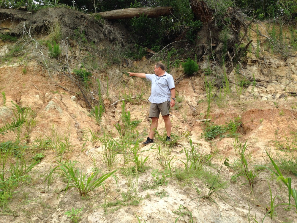
Unusually, in this meander, the bayou deposits sediment on the outside bend, the park side of the stream, causing the bank to widen. (Normally sediment is deposited on the inside bends and picked up on the outside.) But the high outside bluff here is composed in part of very hard, resistant clay. This reversed phenomenon might also in part be the result of the blocking flow of the tributary shooting across the channel during rain events. And Geologist Tom Helm thinks that a fault running through the meander might have caused the bayou channel to shift somewhat to the southeast over time.
Here is a photo of Tom pointing to the downshifted layer of dark red clay in the strata of the face of the high bank, which is part of the tens-hundred-thousand years old late Pleistocene-era meander-belt ridges carved out of the earth at the end of the last glacial period, when giant sloths, zebra horses, and saber-toothed cats roamed through Memorial Park. We still have American alligators (alligator mississippiensis) and alligator gar from that period. The high cut banks of these meander-belt ridges are long-established characteristics of our west-to-east meandering streams in the Houston region and serve as as bumpers slowing the flow. The dark layer Tom is pointing to in the face of the high bank of the middle meander is offset by about three inches, possibly indicating a fault.
-
- Tom Helm pointing to his right. Invasive Johnson grass in foreground.
-

- Tom pointing down to his left. Photos April 29, 2017
Invaders. Pull Them Out!
When we stepped out of the canoe onto the sandy north bank of the meander, we were dismayed to discover invasive Johnson grass growing all over the beach. In the past this lovely sand bank was naturally landscaped with native smartweed, ground cherry and young box elder and black willow, all the proper native vegetation intelligently arranged by the bayou as it worked to stabilize the sediment and plan for new growth. But now this invader was taking over. We had seen it also at the boat launch in Memorial Park at Woodway. Very discouraging. Anyone who wishes to organize Johnson grass-pulling parties is encouraged to do so. The Memorial Park Conservancy unfortunately does not consider maintaining the banks or bayou woods part of its job, instead largely confining routine maintenance activities to mowing down the sedges and other wetland plants in the bogs of the park, leaving behind large, deep ruts. How nice it would be if the Conservancy respected the natural character and landscaping of our park.
A Surprise from the Past
As we inspected the springs that flowed out of the high bank, we were surprised to find a large pile of broken glass bottles and pottery embedded in the mud. The glass was thick and had an old-fashioned shape. The pieces looked very old. Geologist Bill Heins, who explores the banks of the bayou regularly with his dog, suggests that the bottles and pottery had washed out from an old trash dump in a filled gully higher up the bank.
Very possibly the pottery and bottles date from the era of Camp Logan, a World War I military training camp established in 1917, part of which would become Memorial Park after the war. Beginning in August of 1917 there was a large military hospital, as well as a landfill, operating on the north bank of the bayou, eventually occupying over 100 acres of what is now the Hogg Bird Sanctuary and extending westward into what is now the park’s South Picnic Loop, according to Janet Wagner, landscape architect and historian and former chair of the Harris County Historical Society. In 2014 Wagner wrote to the Corps of Engineers about the archeological significance of the bayou in the proposed project area. The hospital, she noted, served some 1,500 men and continued caring for veterans after the war. In 1919 the hospital and buildings were transferred to the Public Health Service, with some of them leased to the newly formed City-County Hospital District. In 1921 the Veterans’ Bureau took over the hospital and two years later began evacuating the veterans to other facilities around the state. One year later, in 1924, Will and Mike Hogg and their real estate partner, Henry Stude, purchased the hospital grounds and then sold at cost a total of nearly 1,500 acres of what had been Camp Logan to the City of Houston for the creation of Memorial Park.
In May of 2013 the Texas Historical Commission designated the former site of Camp Logan a State Archeological Landmark, now known as a State Antiquities Landmark. The designation requires that the landowner receive a permit from the historical commission before conducting any work on the site.
Here are photographs of the glass and pottery remnants we discovered on the bank of Buffalo Bayou in April 2017.
 Very old broken bottles and pottery shards on a bank of Buffalo Bayou in April 2017.


Tracking Wildlife on the Bayou
Boys Scouting Part III
September 20, 2016
Boy Scout Paul Hung rallied his troop for the third floating inventory of the banks of Buffalo Bayou on a recent Saturday morning. Hung is documenting the tracks of wildlife as an Eagle Scout service project, and his fellow scouts in Sam Houston Council Troop 55 are helping.
Hung and other scouts have so far found over 130 tracks of animals including raccoon, beaver, possum, coyote, grey fox, bobcat, great blue heron, egret, otter, nutria, wild boar, and others. The tracks are being plotted on a map, and the information will be published as a pamphlet with the help of Save Buffalo Bayou, which is the beneficiary of the project.
Anyone who wishes to donate to help Paul Hung publish his Buffalo Bayou wildlife pamphlet can do so here.
About a dozen Boy Scouts and adult observers gathered with their Boy Scout wooden canoes at the Memorial Park boat launch at Woodway Sept. 10. It was a steamy morning, and they planned to paddle past Memorial Park and the Hogg Bird Sanctuary all the way to Lost Lake in Buffalo Bayou Park. Hung handed out clipboards and gave instructions for identifying and photographing the tracks and recording their location using a compass app on a cell phone. Nearby was the wooden box, built and recently installed by Troop 55 Boy Scout Saswat Pati, containing reusable bags for picking up trash on the bayou.

Members of Boy Scout Troop 55 headed downstream from the Woodway boat launch in Memorial Park to inventory animal tracks on the banks of Buffalo Bayou. Photo Sept. 10, 2016
State of the Bayou
Downed Trees. New Channel. New Riprap. Washed Out Sidewalks, Beavers, and Turtles
But Some Banks Naturally Rebuilding
Does It Make Sense to Repair?
Sept. 1, 2016
Updated Sept. 11, 2016
You could not step twice into the same river. Heraclitus
We finally had a chance recently to float down beautiful Buffalo Bayou to see how things have changed. Our trip took us past Memorial Park in the middle of Houston. We also biked along the bayou through Terry Hershey Park far upstream in west Houston below the dams to see what was happening there.
The good news is that some of the high banks that had slumped in Memorial Park and the Hogg Bird Sanctuary during the Memorial Day 2015 flooding are naturally rebuilding.
The bad news is that the River Oaks Country Club has added more riprap to the south bank, hard armoring the bank with ugly, damaging concrete rubble, including where it should not be.
Nature’s Miraculous Way of Restoring. For Free.
Houston has had multiple record-breaking rains and flooding since the spring of 2015. When Buffalo Bayou overflows its high banks, as it did in the Memorial Day flood of 2015, the banks in places sometimes slump or slide away. This happens when the overflowing water seeps through the ground and saturates layers of sandy clay that liquefy, sometimes causing the bank to give way. Buffalo Bayou is 18,000 years old, and this has been happening for a very long time.
This natural tendency to slump is one reason why we think attempting to engineer these banks as proposed by the $6 million Memorial Park Demonstration Project won’t work. It’s also the reason why we think building and repeatedly repairing sidewalks at the bayou’s edge is wasteful and foolish.

The south-facing high bank of the Hogg Bird Sanctuary collapsed during the Memorial Day flood in 2015. Now self-restored. Photo on August 4, 2016.
Can An Urban Stream Restore Itself?
Yes, With Room to Move. Free Rivers Are Healthier and Better for Flood Control
June 15, 2016
Updated with August 2016, April 29 and July 11, 2017, photos of self-repaired Hogg Bluff
By Susan Chadwick, Executive Director, Save Buffalo Bayou
This article is adapted from a presentation made at the Southwest Stream Restoration Conference in San Antonio, Texas, on June 2, 2016.
Save Buffalo Bayou is a non-profit organization founded two years ago to fight a public project described as a “restoration” project on one of the last natural stretches of Buffalo Bayou as it flows through the middle of Houston, past 1,500-acre Memorial Park and another 15-acre public nature preserve, the Hogg Bird Sanctuary. Since then our organization has expanded into broader, related issues. But today’s topic is restoration.
Here are some of the most common responses I would get when I would say that this mile-long plus stretch of the bayou is natural, along with what were some of the most common defenses of the project.

Sandy bank on a meander of Buffalo Bayou in Memorial Park. Photo by Jim Olive on April 2, 2016
The river’s not natural because the river changes.
It’s not natural because it’s been altered by high runoff from urbanization.
Trees fall into it.
It has terrible erosion problems. Look at those steep high banks!
It’s terribly eroded. Look at those sandy banks!
It’s eroding terribly. Sediment from the banks in Memorial Park washes up on the sidewalks of Buffalo Bayou Park we built downstream in the floodway right next to the river.
All that sediment carries bacteria. If we stop the banks from eroding so much sediment, we will reduce the bacteria. (Although sediment-laden Buffalo Bayou is less polluted than White Oak Bayou, which runs relatively clear and extremely foul due to being encased in concrete.)
And of course the big one: the river needs to be stabilized because it moves around.
Then there’s the argument, both implied and explicit, that prompted me to select this topic for presentation today: an urban stream cannot restore itself.
A Profound Misconception About How Nature and Rivers Work
All of those statements, of course, indicate a profound misconception about nature, about how a river works and how rivers benefit us.
A river is a living symbol of change. A living system. A dynamic process of nature that works for our benefit. Even the simple grains of sand work on our behalf to cleanse the water.
Once-a-Boat-Launch at Woodway to Re-Open by Mid-December
Meanwhile Buffalo Bayou Busy Replanting, Beautifying
Sept. 5, 2015
A contractor has been found at last to take down the heavy-duty chain-link construction fencing, put up some railing, spread some gravel and sod, and restore the informational sign in that western part of Memorial Park that was once a popular boat launch and is now referred to by public officials as a drainage outfall.

Native, edible amaranth in the foreground planted by Buffalo Bayou on the bank of the Woodway drainage outfall. Smartweeds, snoutbean, and other plants, mostly native but also some invasive, in the background. Native plants like amaranth and smartweed stabilize the soil and help prepare for new forest growth. Non-native Bermuda and St. Augustine grasses planted by contractors. Photo Aug. 28, 2015
Closed to the public for more than two years, including more than a year after the $1.36 million taxpayer-funded solar-irrigated “erosion control” project was completed, the ugly, massively enlarged outfall draining Post Oak Road is still officially a Texas Parks and Wildlife Paddling Trail boat launch. Previously it was also a forested area with a nature trail.
But officials with the Uptown Tax Increment Reinvestment Zone (TIRZ) 16 now seem genuinely eager to do “what we can to get it open to the public,” said John Breeding, administrator, at the Uptown board meeting in a Galleria high-rise last Wednesday, Aug. 26.
The board voted without discussion to award a contract for $219,272.10 to Jerdon Enterprise, LP, which was the sole bidder for the long-delayed project. With “add-ons” the cost could go to $335,615.10. That seems like a lot of public money for taking down some chain-link fencing, putting up some standard railing, laying down some loose gravel, etc. But apparently no one else wanted to do it.
Work on the Outfall Phase II is now scheduled to begin this month and be completed by December 15, 2015.
And if you’re confused about why a TIRZ and not the parks department or the city council would be making these decisions, well, it is confusing. But the TIRZ has control of the money.

Recent Comments