Breaking News: Trash Washes Up From Early Twentieth Century
Old Bottles Surface on the Banks of the Bayou
Site is a State Antiquities Landmark
Bonus: Some Geology and History
May 18, 2017
On a recent trip down Buffalo Bayou, pausing to document the springs seeping out of the banks, we stopped at one of our favorite spots: the wide sandy bank of what we call the middle meander — so named because it’s the middle meander in that 1.25-mile long stretch of the forested bayou targeted for destruction by the Harris County Flood Control District.
This sharp bend in the river is located at the eastern boundary of Memorial Park, with a small tributary flowing into it and very old high banks on the downstream side. It is a natural stormwater detention area, and elsewhere the flood control district is spending millions to build detention basins in or near our bayous. But here the district’s plan is to spend millions to fill in a detention area and dig a new channel for the bayou through the woods on the south bank of the bayou owned by the River Oaks Country Club. Why the members of the club would agree to that is a mystery. The plan also calls for grading the ancient high bank, leveling the area, and planting it all with turf grass. An access road for heavy construction equipment would be bulldozed through the public forest from the maintenance yard near Memorial Drive to the bayou.
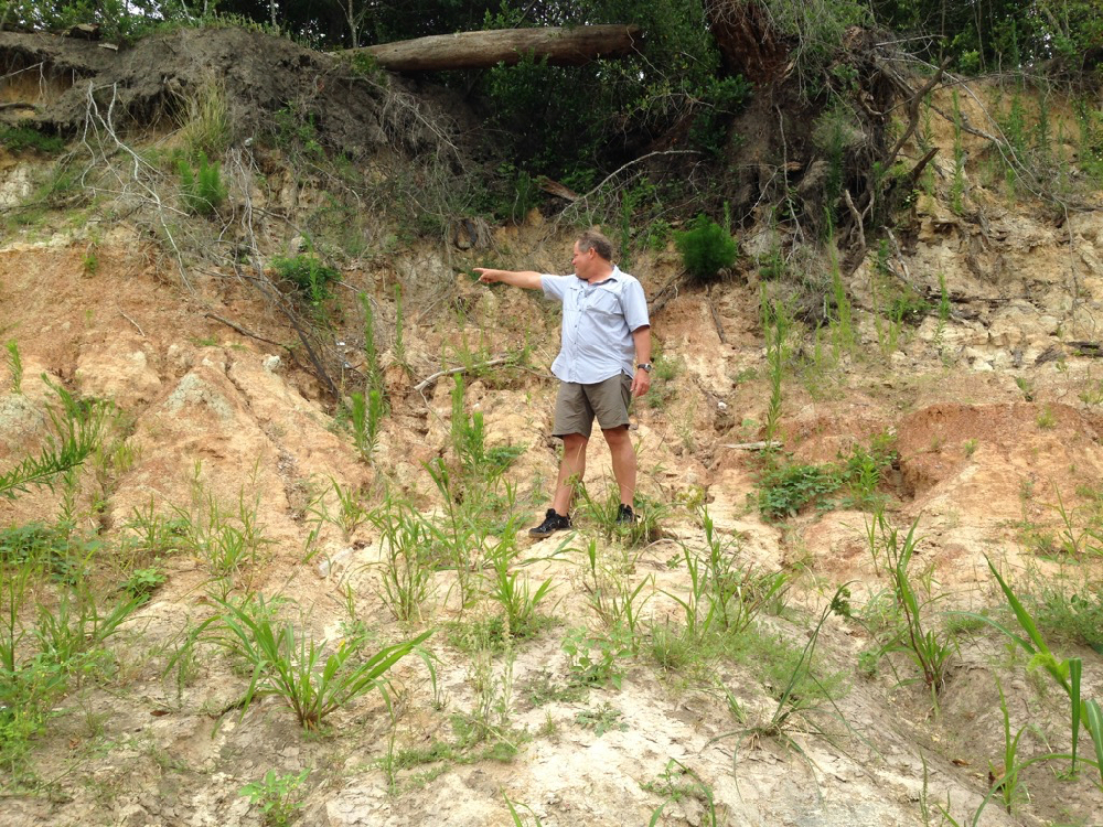
Unusually, in this meander, the bayou deposits sediment on the outside bend, the park side of the stream, causing the bank to widen. (Normally sediment is deposited on the inside bends and picked up on the outside.) But the high outside bluff here is composed in part of very hard, resistant clay. This reversed phenomenon might also in part be the result of the blocking flow of the tributary shooting across the channel during rain events. And Geologist Tom Helm thinks that a fault running through the meander might have caused the bayou channel to shift somewhat to the southeast over time.
Here is a photo of Tom pointing to the downshifted layer of dark red clay in the strata of the face of the high bank, which is part of the tens-hundred-thousand years old late Pleistocene-era meander-belt ridges carved out of the earth at the end of the last glacial period, when giant sloths, zebra horses, and saber-toothed cats roamed through Memorial Park. We still have American alligators (alligator mississippiensis) and alligator gar from that period. The high cut banks of these meander-belt ridges are long-established characteristics of our west-to-east meandering streams in the Houston region and serve as as bumpers slowing the flow. The dark layer Tom is pointing to in the face of the high bank of the middle meander is offset by about three inches, possibly indicating a fault.
-
- Tom Helm pointing to his right. Invasive Johnson grass in foreground.
-

- Tom pointing down to his left. Photos April 29, 2017
Invaders. Pull Them Out!
When we stepped out of the canoe onto the sandy north bank of the meander, we were dismayed to discover invasive Johnson grass growing all over the beach. In the past this lovely sand bank was naturally landscaped with native smartweed, ground cherry and young box elder and black willow, all the proper native vegetation intelligently arranged by the bayou as it worked to stabilize the sediment and plan for new growth. But now this invader was taking over. We had seen it also at the boat launch in Memorial Park at Woodway. Very discouraging. Anyone who wishes to organize Johnson grass-pulling parties is encouraged to do so. The Memorial Park Conservancy unfortunately does not consider maintaining the banks or bayou woods part of its job, instead largely confining routine maintenance activities to mowing down the sedges and other wetland plants in the bogs of the park, leaving behind large, deep ruts. How nice it would be if the Conservancy respected the natural character and landscaping of our park.
A Surprise from the Past
As we inspected the springs that flowed out of the high bank, we were surprised to find a large pile of broken glass bottles and pottery embedded in the mud. The glass was thick and had an old-fashioned shape. The pieces looked very old. Geologist Bill Heins, who explores the banks of the bayou regularly with his dog, suggests that the bottles and pottery had washed out from an old trash dump in a filled gully higher up the bank.
Very possibly the pottery and bottles date from the era of Camp Logan, a World War I military training camp established in 1917, part of which would become Memorial Park after the war. Beginning in August of 1917 there was a large military hospital, as well as a landfill, operating on the north bank of the bayou, eventually occupying over 100 acres of what is now the Hogg Bird Sanctuary and extending westward into what is now the park’s South Picnic Loop, according to Janet Wagner, landscape architect and historian and former chair of the Harris County Historical Society. In 2014 Wagner wrote to the Corps of Engineers about the archeological significance of the bayou in the proposed project area. The hospital, she noted, served some 1,500 men and continued caring for veterans after the war. In 1919 the hospital and buildings were transferred to the Public Health Service, with some of them leased to the newly formed City-County Hospital District. In 1921 the Veterans’ Bureau took over the hospital and two years later began evacuating the veterans to other facilities around the state. One year later, in 1924, Will and Mike Hogg and their real estate partner, Henry Stude, purchased the hospital grounds and then sold at cost a total of nearly 1,500 acres of what had been Camp Logan to the City of Houston for the creation of Memorial Park.
In May of 2013 the Texas Historical Commission designated the former site of Camp Logan a State Archeological Landmark, now known as a State Antiquities Landmark. The designation requires that the landowner receive a permit from the historical commission before conducting any work on the site.
Here are photographs of the glass and pottery remnants we discovered on the bank of Buffalo Bayou in April 2017.
 Very old broken bottles and pottery shards on a bank of Buffalo Bayou in April 2017.


State of the Bayou
Downed Trees. New Channel. New Riprap. Washed Out Sidewalks, Beavers, and Turtles
But Some Banks Naturally Rebuilding
Does It Make Sense to Repair?
Sept. 1, 2016
Updated Sept. 11, 2016
You could not step twice into the same river. Heraclitus
We finally had a chance recently to float down beautiful Buffalo Bayou to see how things have changed. Our trip took us past Memorial Park in the middle of Houston. We also biked along the bayou through Terry Hershey Park far upstream in west Houston below the dams to see what was happening there.
The good news is that some of the high banks that had slumped in Memorial Park and the Hogg Bird Sanctuary during the Memorial Day 2015 flooding are naturally rebuilding.
The bad news is that the River Oaks Country Club has added more riprap to the south bank, hard armoring the bank with ugly, damaging concrete rubble, including where it should not be.
Nature’s Miraculous Way of Restoring. For Free.
Houston has had multiple record-breaking rains and flooding since the spring of 2015. When Buffalo Bayou overflows its high banks, as it did in the Memorial Day flood of 2015, the banks in places sometimes slump or slide away. This happens when the overflowing water seeps through the ground and saturates layers of sandy clay that liquefy, sometimes causing the bank to give way. Buffalo Bayou is 18,000 years old, and this has been happening for a very long time.
This natural tendency to slump is one reason why we think attempting to engineer these banks as proposed by the $6 million Memorial Park Demonstration Project won’t work. It’s also the reason why we think building and repeatedly repairing sidewalks at the bayou’s edge is wasteful and foolish.

The south-facing high bank of the Hogg Bird Sanctuary collapsed during the Memorial Day flood in 2015. Now self-restored. Photo on August 4, 2016.
How Old Is Buffalo Bayou? Where Does It Come From?
Geology Lessons on the Bayou
March 27, 2016
Want to learn about the geology and natural history of Buffalo Bayou?
Save Buffalo Bayou is partnering with professional geologist Tom Helm, who also happens to be an outstanding naturalist and river guide, to offer floating classes on the geology of our 18,000-year-old mother bayou.
Paddle with Tom on a two-hour canoe trip down Buffalo Bayou and see some of our Pleistocene natural history right here in the middle of Houston. Learn all about the formation of the bluffs and sandstone rocks during the last ice age. See examples of depositional environments and fluvial processes. Find out why the banks are sandy and how sand moves downstream, why the river looks the way it does, and much more.

Geologist Tom Helm explaining 500,000-year-old sandstone on Buffalo Bayou. Photo taken March 18, 2016
Where, When, Cost
The classes start at the Woodway boat launch in Memorial Park and float past the park and the Hogg Bird Sanctuary, through the historic natural area targeted for destruction by the Harris County Flood Control District. Multiple stops will be made along the way to examine features of interest.
The schedule depends on class size. One to four persons can be scheduled any day of the week, usually with no more than 48 hours’ notice. Groups larger than four persons (up to 30 persons maximum) are accepted only on weekends. These larger weekend groups need to schedule at least one month in advance.
Cost is $50 per person, which includes canoe and equipment, and light refreshments at the end. Discounts are available for academic faculty and students.
Note that the classes will be not take place if the flow of Buffalo Bayou is greater than 300 cubic feet per second (as measured by the Piney Point USGS gauge). At water levels above this, the sandstones are mostly obscured. If a trip is cancelled due to high water, students have the option of rescheduling or receiving a full refund.
For more information, contact Tom Helm.
Some Things We Learned Already: Why Mud Stinks
We floated with Tom recently for a preview of the geology class. Among the things we learned is why some of the mud stinks. The mud and the sand are filled with layers of organic matter, leaves mostly, and as the organic matter decomposes, it smells like … decomposing stuff. But it also builds soil for future vegetation. This process produces the mysterious oily sheen that you see floating on top of the mud sometimes.
We also learned to tell mud from sand from silt. (Hint: it’s a matter of the size of the grains.) Tom showed us how geologists rub the mud between their thumb and fingers to feel the size of the grains.
We studied the patterns in the sand, watched the grains of sand moving in the water, and learned about eddies and sediment deposition and transport. We saw a lot of animal tracks.
We learned to put the constantly changing bayou in the context of its natural process.
In every outthrust headland, in every curving beach, in every grain of sand there is the story of the earth.
― Rachel Carson
Possible Alligator Tracks
A Small Alligator On Buffalo Bayou
March 19, 2016
We were out on the bayou Saturday morning with geologist/naturalist river guide Tom Helm for a geology lesson about Buffalo Bayou and how rivers work. Save Buffalo Bayou is going to be offering classes on the bayou in conjunction with Helm, as well as nature photography classes with professional photographer Jim Olive. More about that soon.
It was a beautiful morning, and the water flow was relatively low, around 500 cubic feet per second (cfs), not great for seeing a lot of geologic formations on the lower banks of this historic natural area, but good enough. We saw a lot of tracks, including what may have been the tracks of a small alligator climbing out of the water in the mud of the Woodway boat launch in Memorial Park. Tom estimated it could have been about four feet long. Tom, who floats the bayou as often as several times a week, said he hasn’t seen an alligator in the bayou in a couple of years, and the last one was also small, although some people may not think a four-foot alligator is small.

Tracks possibly of small alligator emerging from water at the Woodway boat launch in Memorial Park March 18, 2016.

Recent Comments